• Facebook
  • Twitter
  • Subscribe
  • RSS

Evacuations Ordered in Hawaii


Hawaii is bracing for the first wave of the tsunami that has been produced by the massive earthquake that struck Japan last night:

(Reuters) – Hawaii ordered evacuations of its coastal areas and braced for a possible tidal wave set off by Friday’s earthquake in Japan as a tsunami warning was extended to most of the Pacific basin, including northern California and Oregon.

Some 3,800 miles (6,200 km) from Japan, the main airports on at least three of the major Hawaiian islands — Maui, Kauai and the Big Island of Hawaii — were shut down as a precaution, and the U.S. Navy ordered all warships in Pearl Harbor to remain in port to support rescue missions as needed.

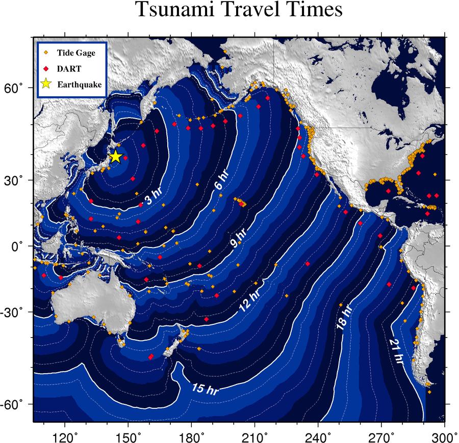
The graphic above is from the West Coast/Alaska Tsunami Warning Center. It illustrates the travel times of the tsunami to various regions around the Pacific Rim.

It’s important to remember that a tsunami isn’t just a single wave but a series of waves and the interval between them may range from minutes to hours. The earthquake that struck Japan is of historic magnitude. Consequently, the tsunami it produced may well be, too. It may cause coastal flooding not only in Hawaii but in Washington, Oregon, and California or it may not. At this point noone really knows for sure.

Judging by the energy map of the tsunami the U. S. West Coast is likely to escape the brunt of the tsunami’s force but Chile may well be in for a rough time.

UPDATE

The first waves to reach Hawaii are being reported as three feet but subsequent ones are expected to be larger.

Related Posts

About Dave Schuler
Over the years Dave Schuler has worked as a martial arts instructor, a handyman, a musician, a cook, and a translator. He's owned his own company for the last thirty years and has a post-graduate degree in his field. He comes from a family of politicians, teachers, and vaudeville entertainers. All-in-all a pretty good preparation for blogging.

Comments

  1. Drew says:

    The first wave was only 2 feet, although subsequent waves could be larger. Interestingly, in So Cal they have put a ship out to sea a/c shallow waters. I trust jp and MR will not suffer flooding.

    In Japan they reported a 33 feet wave. Wow.

    Helpful or Unhelpful: Thumb up 0 Thumb down 0

  2. Dave Schuler says:

    If the energy map linked above is correct most of the force of the tsunami will pass to the south of the mainland U. S.

    Helpful or Unhelpful: Thumb up 0 Thumb down 0

  3. Drew says:

    Its typical. The news agencies gather experts and clear up alot of the early speculation. The most important note I heard: underwater topology can effectively concentrate the wave energy. As I understand it that’s the concern for certain sections of So Cal, and as Dave S points out, certain sections of S America.

    Amazing how fast and efficiently water can transfer energy. After all, its not compressible. Welcome to the science of hydraulics…..

    Helpful or Unhelpful: Thumb up 0 Thumb down 0

  4. JKB says:

    PTWC is reporting 5.7 ft in Kahului, Maui, 3 ft in Hilo. West Coast US with rapid rise from deep water should be okay although they should be looking to rapid tidal-like currents in the harbors and of course, stay out of the water at the beach.

    Helpful or Unhelpful: Thumb up 0 Thumb down 0

  5. Drew says:

    Again, its typical. If you channel surf you get everything from the US west coast will be unaffected………to 10 foot waves.

    I guess we’ll find out soon.

    Helpful or Unhelpful: Thumb up 0 Thumb down 0

  6. JKB says:

    Well the problem is that the West Coast of the US is the responsibility of the Alaska Tsunami Warning center and they don’t seem to be putting out useful information. Their bulletins keep coming up file not found. So we’ll just have to wait for news reports since the people with the data downloads from the gauges aren’t getting information out.

    Maybe PTWC who has responsibility for the rest of the world will include some info in their bulletins.

    Helpful or Unhelpful: Thumb up 0 Thumb down 0

  7. JKB says:

    Historically, the biggest impacts on the West Coast were around Crescent City. The sharp depth change near the coast, cuts off a lot of the energy causing less impact on the West Coast shoreline. There is localized funneling though.

    Helpful or Unhelpful: Thumb up 0 Thumb down 0

  8. Drew says:

    JKB -

    Now that the news people have gotten some competant people on, that seems to be the story…..

    Helpful or Unhelpful: Thumb up 0 Thumb down 0

  9. JKB says:

    I did find the calculated heights (in plain sight) with projects of 2.5 m at Crescent City. The only reporting station I saw was the northern tip of Vancouver Island coming in just below projections of .4 m

    Helpful or Unhelpful: Thumb up 0 Thumb down 0

  10. [...] Evacuations Ordered in Hawaii (outsidethebeltway.com) [...]

    Helpful or Unhelpful: Thumb up 0 Thumb down 0

  11. JKB says:

    PORT SAN LUIS CA 35.2N 120.8W 1654Z 1.88M / 6.2FT 22MIN
    CRESCENT CITY CA 41.7N 124.2W 1657Z 2.02M / 6.6FT 20MIN

    6.6 ft – That’s not something to be surprised with. That seems to be the highest reported from Alaska to California so far.

    Helpful or Unhelpful: Thumb up 0 Thumb down 0

  12. Franklin says:

    Not to make light of any of this, but that energy map is really neat.

    Helpful or Unhelpful: Thumb up 0 Thumb down 0

  13. Drew says:

    aso not to make light, but life moves on: Japan buys treasuries. Impact on US Treasury rates?

    Helpful or Unhelpful: Thumb up 0 Thumb down 0