More on Alabama Districts
Diving into the structure of Alabama's districts and highlighting deep problems.
I wanted to write about the SCOTUS ruling regarding Alabama’s US House districts yesterday but did not have the time. James Joyner beat me to it this morning, but let me talk about it from a slightly different perspective.
Here’s a useful map from an AP story about the case from last year:
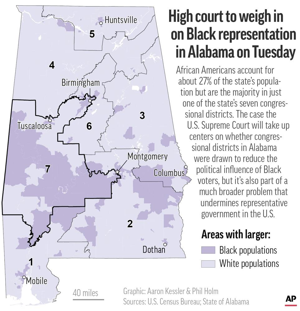
So, for those unfamiliar with the state, the peninsula at the top right of the AL07 is reaching into the Birmingham metro area to capture a lot of numbers. Also, AL07 and AL02 split the majority Black Montgomery County and specifically encompass the west side of town, which is heavily Black. These two scoops of urban areas are combined with the more rural communities in the Black Belt region to the west.
The region is so-called because of the soil. And to show how various factors work together for long-term consequences, the soil of the Black Belt made it ideal for cotton farming, and hence used to house a lot of plantations fueled by slave labor). It is not hyperbole to note that socio-economic choices made in the 1800s, based on much longer-term geological developments, are directly affecting both rural poverty in Alabama, but also political choices.
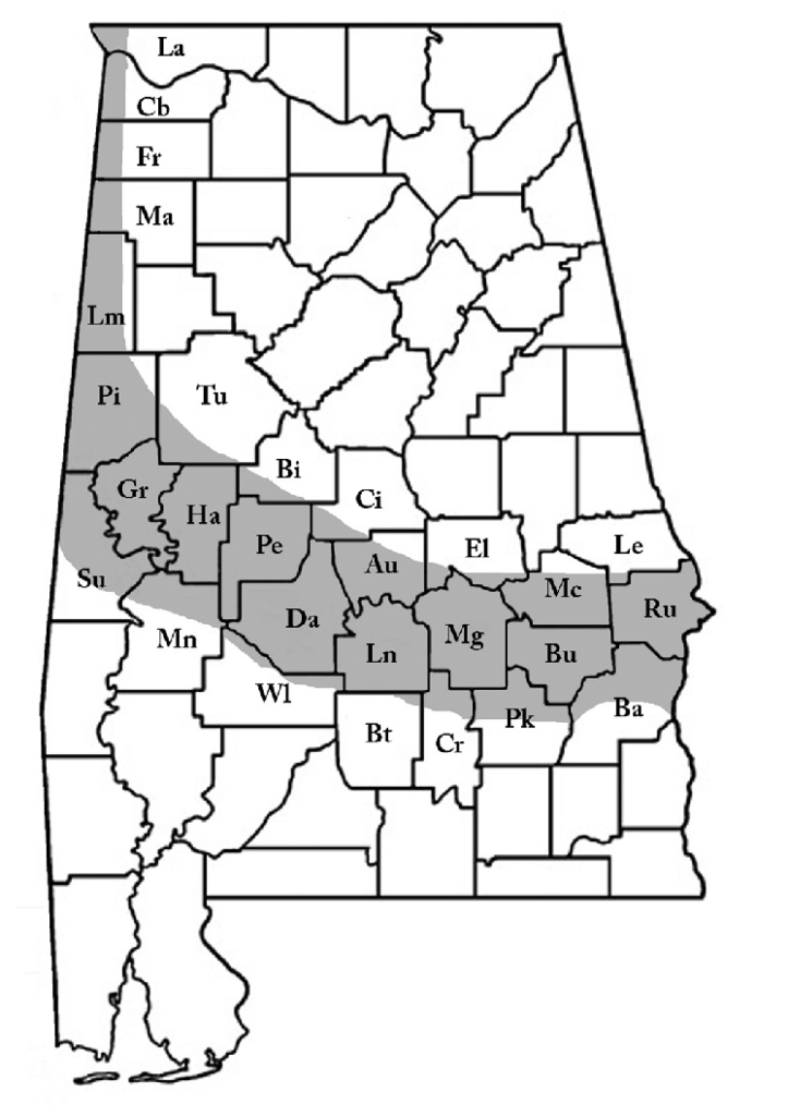
Indeed, the way in which soil type can be linked to a specific socio-economic system (plantation slavery) and then to the manifestation of rural poverty we find in the region given the collapse of the plantation system and the way freed Black were treated after the Civil War all combine to be great examples of how structural factors can contribute to long-term social consequences.* It is a great example of how the effects of slavery, the Civil War, and post-Reconstruction all combine to have real-world effects in the here and now (despite the fact that many people want to pretend like the past is far distant and should not come into discussions of contemporary politics).
But I digress, at least somewhat.
Back to the districts, it is worth pointing out that even over the time that I have lived in the state (two months-ish shy of 25 years), the Montgomery metro area has been a pawn in the packing and cracking game of the legislature, as at one point AL03 converged with AL07 and AL02.
A historical note, the Republicans did not take control of state government until 2011:

(Source)
Now, as James noted in his post, there has long been one main Black district in the state (AL07), but it is also true that the alignment of racial politics and partisan preferences in terms of guiding the districting process is more recent. I would argue that this shift, even allowing that a lot of Democrats in state government prior to 2011 were quite conservative, has reinforced the motivation to contain the influence of Black voters because Republicans know that Black voters are overwhelmingly Democratic voters.
There is little doubt that map shown above is designed to heavily concentrate Black voters into one district (AL07) to dilute Black populations in the remaining districts. In my view as a theorist of democracy, rather than from the legal approach that is guiding the overall discussion, the most egregious examples of this are the ways in which populations in Birmingham and the Montgomery are split off. From a representational point of view, it should be the case that the Birmingham area, as a whole, should have more direct representation in Washington, and likewise the Montgomery area. These are distinct regions and important population centers. Instead, both metro areas are deliberately split into two districts. This damages, in my view, representational quality, because the needs of Birmingham residents, Montgomery residents, and those of the rural Black Belt are not the same.
I would point to a piece that I wrote for the Pulaski Institution: Alabama: Lack of Competition and Election Skepticism Down South which focuses more on the obvious partisan bias in Alabama politics, but it is one that correlates well with the racial aspects of the SCOTUS case.
Alabama has seven US House seats. If those seats were allocated proportionally based on the state’s partisan breakdown of ~60:40, the delegation ought to be four Republicans and three Democrats (even using the 70:30 ratio, the delegation should be split five to two). Instead, that ratio is six Republicans and one Democrat (i.e., 86% of the state’s House delegation is Republican). What we see here is a pathology common across the US: the way in which single-seat districts limit competitiveness both naturally and by design.
In terms of the natural distribution of voters, Democrats are heavily concentrated in cities, and single-seat districts tend to blunt the impact of cities in general. Moreover, long-term residential patterns dating back to the plantation/slavery era concentrate Black residents along the Black Belt of the state (so-called due to the soil), which makes up a substantial portion of the heavily-Democratic Seventh District.
The “by design” part of the equation is that the districts have been gerrymandered by the Republican-controlled state legislature to maximize Republican outcomes. The aforementioned Seventh District, for example, not only contains substantial portions of the Black Belt but is drawn in a way that taps into heavily Black neighborhoods in the state capital, Montgomery, as well as significant portions of the Birmingham metro area. It is a classic case of packing a district with partisan affiliates.
Not only is there a representativeness problem, but there is also a competitiveness problem:
Indeed, all seven of Alabama’s congressional districts in the 2020 elections were non-competitive because each was heavily tilted towards one party. The closest race was in AL01, which the Republican candidate won by a margin of 28.83%. The average margin of victory across all seven races was 62.73% and three of the races only had one of the major parties running a candidate. In the simplest of terms: there is no competition for US House seats in Alabama, but instead, the district lines dictate the outcome, so the only contests of significance would have been at the primary level. These same parameters will be in play with the new maps going into effect for the 2022 contests.
The real problem here is the usage of single-seat districts, and so even if fairer maps are drawn, they are highly unlikely to actually be fair, let alone competitive.
This is hardly a new revelation for me:
- It’s the Single-Seat Districts
- Single-Seat Districts are a Huge Problem
- The Lack of Competition for House Seats
- Speaking of Reform
(And that is just some recent-ish examples).
I am heartened, to a degree, about this ruling. But I am also fully confident that it is not going to fix the fundamental problem.
*Fun fact about the Black Belt: the soil quality is a direct result of where the coastline of Alabama used to be. So, long-term geological issues have impacted where House districts are drawn in the Twenty-First Century. See this quite fascinating run-down from 2012 in the Deep Sea News: How presidential elections are impacted by a 100 million year old coastline.


Interesting background on an interesting situation. Thank you!
For several years I have been toying with the idea of how to best randomize the redistricting process.
Originally my thought was to allow no more than 6 or perhaps 8 corners to a district – otherwise it had to be straight lines.
These days I’m thinking we’d be better off with completely straight lines from the western border to the eastern border of each state – with the line situated in a position that gave equal populations to each district. If a state stops and restarts east-to-west, then the latitude of the straight line continues as if it were continuous.
Somebody might find a way to gerrymander that, but it wouldn’t be as bad as what we see today.
@Tony W: 538 had a pretty good series that noted that there is no fair way to draw districts.
And I would suggest that population patterns make what you are describing to be impossible.
@Steven:
I think this is unassailable. Going back to at least Baker vs Carr (which established the “one man, one vote” principle), though, the Supreme Court has held that community is not a central precept of districting as a matter of law. Over the years, the Court has imposed various restrictions—each of a state’s districts should be roughly equal in the number of people represented, they have to be contiguous, reasonably compact, etc. While race per se can’t be a primary consideration, gerrymandering for partisan manipulation is very much allowed.
What’s legal and what’s just, of course, aren’t the same thing. And, indeed, the central problem is the single member district itself.
@Steven L. Taylor:
I heard the 538 redistricting podcasts.
As I recall, things worked well when a clear purpose was set, like making districts competitive or preventing incumbents from having cakewalk reelections.
Me, I keep coming back with one idea:
Set up a commision made up of equal numbers of Republicans and Democrats, and divide them into team Red and team Blue.
One team will draw the map, the other has sole approval.
As in football, there’s a coin flip. The winner decides whether it wants to draw or approve.
If the map is approved, well and good. If it’s not, the approval team can suggest changes, or take its turn drawing. If the latter, the other teams has the approval now.
There are two immediately obvious problems:
1) provisions of the Voting Rights Act would complicate matters.
2) It will never, ever happen.
@Tony W: @Steven L. Taylor: I can pretty much assure you that such a plan would not work in Washington State, where roughly 60% of the population lives in 4 or 5 counties on the western shore of Puget Sound, but not evenly distributed across them. The area immediately bordering both sides of Lake Washington has 4 districts itself.
@James Joyner: No argument from me. Part of the problem is, in my view, what’s legal.
@Kathy:
It depends, very heavily, on the definition of “well.”
@just nutha: Granted, I only gave it a passing thought, but I was trying to think about how some geometric requirement would work to district the Houston area (or similar urban area).
@Kathy: In short, you can make the system better. But you really can’t make it fair. There will be some kind of bias built into any single-seat district scheme.
This is simply a fact.
@Steven L. Taylor:
I would settle for that, as changing from single-seat districts to anything else is far less likely.
@just nutha: That problem goes away if you use an “isodemographic” map, a cartograph in which area is proportional to population, not acreage. The whole “Dems have to be underrepresented because they live in cities” thing goes away.
@just nutha: My lines would be very thin running through Seattle/King County, but I think it could work.
@Tony W: Even so, it appears from the blow up of the district map that only two or 3 counties have district boundaries cutting into them. In terms of contiguous lines/gerrymandring-free districting, Washington’s map looks pretty clean. “If it’s not broken don’t fix it” comes to mind.
@gVOR08: Can’t say for sure, but based on the map from the source I provided, I suspect that you’d probably find a good (as in favorable) comparison between the Congressional districts and an isodemographic map of the state.
@gVOR08:
Proposal DOA. Too many syllables.