PNW Winter in June: Not Since 1894
The weather has been blustery
Now almost a week and a half into June, the weather is acting like winter or early spring. A vigorous area of low pressure has been bringing showers, thunderstorms and strong winds to the region.
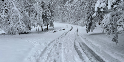
But even stranger is the snow. Numerous winter warnings and advisories are up for the possibility of heavy mountain snow. Up to a foot of snow is possible in the Washington Cascades, with snow levels as low as 2,000′. Look for snow at all the passes, but heaviest amounts will fall above 3,500′. Snow can also be expected in the mountains of northeast Washington, north Idaho and the Blues in northeast Oregon. In those areas, snow will fall above 4,000-5,000′. Meanwhile, very strong winds will continue in eastern Washington and Oregon.
Luckily, this should be short-lived. The low pressure system responsible for all this June “fun” exits by the middle of the week, leaving most of Wednesday and Thursday with partly cloudy skies and warming temperatures.
In two days, this system will hit the Great Plains and Midwest. Combined with gulf warm air there will be tornadoes. Hmm, no idea what happened in 1894, but weather happens. Imagine that.