Black Helicopters Of Huangyangtan
Brought to you by Google Earth.
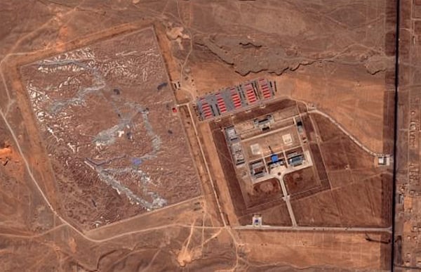
Those among you who like your skies darkened by black helicopters are invited to mosey on down to the remote Chinese village of Huangyangtan which hosts what must be the strangest military installation ever spotted by the Google Earth Community … Zooming in for a closer look, we have what appears to be a 900x700m scale model of a mountainous landscape […] complete with lakes, valleys and snow-capped peaks.


Do we know if the terrain matches another location? maybe here int he US?
It’s a model of land in the Himalayas China holds that is claimed by India. Most likely it’s used for training.
From the Google Earth article:
The Google Earth article has a handful of pics comparing the model with the real topography. Pretty interesting stuff.
Someone might want to mention to the Chinese military the great improvements in computer graphics and their application to pilot mission training.
On the other hand, at least it’s not Mt Fuji or Pikes Peak.
Terrain models are use for ground forces as will. We use them all the time and the more accurate the better to visualize. Computer models are fine when one or two is looking at it but get a dozen or more and it gets to be a hassle. Also many prefer and can visualized better in a large mock up like the one shown which is probably use by the Army and not the Air force.
Wayne,
That makes more sense than pilot terrain familiarization. A 50 to 1 scale is an interesting one. A 50 foot ridge would be 1 foot tall. So standing a nominal 6 feet above the ground would be like flying over it at 300 feet.
I’m still not sure the expense would be justified, though I suspect the cost (probably primarily manpower) would be cheaper in China vs the technology intensive way the west would have used computers.
Go to Fort Bragg or Fort Benning and hang out a while. You will find the U.S. still using terrain models quite extensively. Not as big as the Chinese have here but they are more useful and convenient than Computers at times.