TEXAS: IT’S LIKE A WHOLE OTHER COUNTRY
PoliBlogger has been writing a bit here lately about the strange goings on in the Texas Legislature, where Democrats have staged a walkout. Kevin provides an interesting map that illustrates the redistricting controversy.
If this is correct, the districting plan shown clearly violates recent Supreme Court guidance that districts have to be contiguous and all that. Those cases were in the context of racial gerrymandering–so-called “majority minority districts”–so it’s possible that the fact that race isn’t an explicit factor obviates those rulings here.
Update: As noted in the comments section, the maps and Kevin’s description of what it shows are at odds. I concur with PoliBlogger that this district is almost certainly defensible.


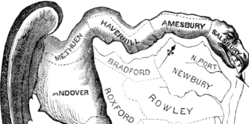
To be honest, looking at that map it doesn’t strike me as a particularly unusual district (now, that isn’t to say that there can’t be a political argument about it–and it also speaks to some of the wild districts that one can find). But, having done some limited study of districts, I don’t think that one would create geographical contiguousness problems.
Also, the Court has ruled that just showing political advantage is not enough to rule a district illegally gerrymandered.
Actually, I think you’re right on contiguity. (No question on the poltical advantage issue; I’m not sure how one could draw a district that didn’t advantage one party over another.)
I was misled by Kevin’s description and looked at the map wrong–I was thinking it was the two purple areas rather than the yellow. Indeed, that district looks a lot better than the Alabama 7th CD.
The “mile wide strip” doesn’t connect two pieces but merely extends from the end of the district. The remainder looks to perfectly correspond with county (parish?) lines.